Clay County, Indiana
2024 Land Sales Report
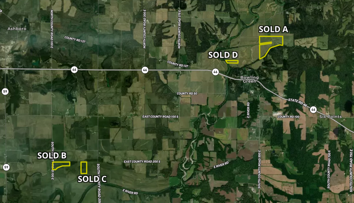
After consistent gains in recent years, Clay County land values rose again in 2024, but the momentum appears to be tapering in early 2025.
If you’d like to get specific land values on your own property or a farm near you for 2025, please call (765) 426-6666.
Request a Land Values ReportAverage Price of Land*
$8,004/acre
Jan. – Dec. 2024*
As high as $9,222/acre
in 2024*
Land Market Commentary & Local Trends
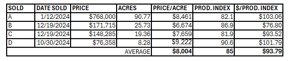
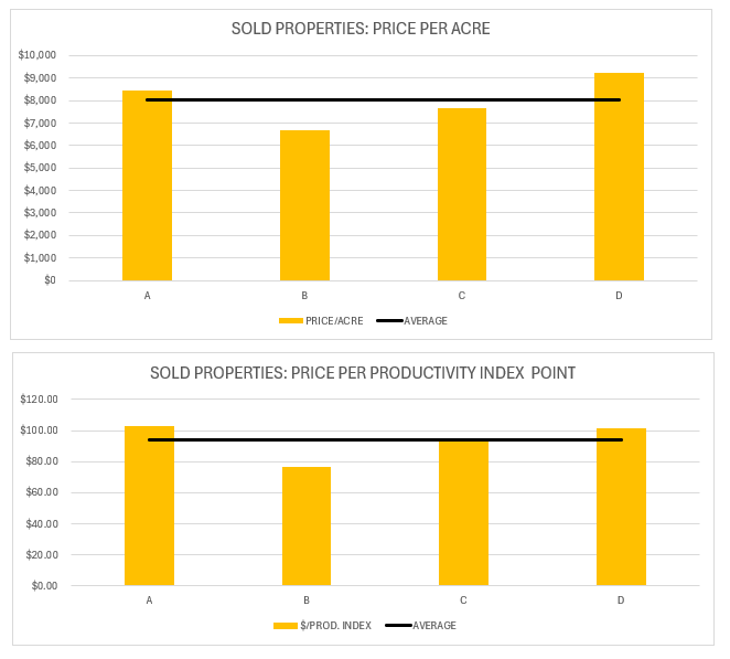
Overall, the average price of farmland was $8,004/acre and the price per productivity index point was $93.79 in 2024 based on the sales data. It is important to note that in 2024 there have been farmland sales as high as $9,222 per acre.
Since 1977, the Geswein Farm & Land Team has been advising landowners to be stewards of the land and make decisions based on most current, accurate, and relevant data. The information in this report can provide you with a rough estimate of your property’s value; however, understanding the specific characteristics of your property and how they compare to the other sales will provide the most accurate value of your property. Additionally, properties sold by land brokers via auctions or listings consistently outperformed individual to individual transactions and properties sold by traditional home realtors.
By The Numbers
According to Land.com, nearly 2,000 acres of land were listed for sale in Clay County, Indiana, totaling close to $27 million in available rural properties. That puts Clay County at 58th out of Indiana’s 92 counties in terms of land currently on the market. A couple of properties were also recorded as sold through the Land Network Comparable Sales Program. Among all areas in the county, the city of Brazil had the most listings. When it comes to the local economy, manufacturing and related industries play a major role in driving growth. Clay County covers about 360 square miles, making it the 70th largest county in the state. It’s situated in the western part of Indiana and offers a mix of small-town charm, open farmland, and industrial influence.
The most recent USDA farmland census reveals that Clay County has 416 farms managing approximately 173,429 acres, with the average farm size landing around 417 acres–one of the larger averages in the state. The county’s farmland is heavily focused on crop production, which makes up the bulk of farm income, while livestock and related operations account for a smaller segment. On the conservation front, many Clay County producers are adopting soil-friendly strategies: about 36% use no-till, 25% rely on reduced tillage, 24% intensive tillage, and 8% plant cover crops to support long-term productivity and environmental stewardship.
Overview of Clay County Agriculture
Location and Geography: Clay County is located in west-central Indiana, nestled between Vigo and Owen counties. The county features a mix of gently rolling farmland, forested areas, and river valleys, with the Eel River flowing through its eastern half and a landscape shaped by glacial and coal-mining history.
Major Crops:
- Corn: leading crop in Clay County, with many local farms dedicated to producing it for grain and livestock feed.
- Soybeans: widely planted across the county, often rotated with corn to maintain soil health and boost yields.
- Wheat: also grown in the area, though in smaller quantities, serving both as a cash crop and a useful option for double cropping.
- Hay: production supports the county’s livestock operations, especially in areas with less intensive row cropping.
Clay County supports a substantial agricultural presence with 416 farms covering about 173,429 acres, and a robust average farm size of 417 acres, ranking among the state’s larger farm operations. The county’s farms are solidly crop-focused, with the majority of income coming from field crops, through livestock remains part of the mix. Local producers are also adopting conservation practices on a meaningful scale–approximately 36% of farms use no-till, 25% rely on reduced tillage, 24% practice intensive tillage, and 8% plant cover crops–indicating a strong commitment to long-term soil and environmental health.
Clay County’s land market stays active but measured. Recent data shows about 1,133 acres listed, with average parcel sizes around 47 acres and median lots of about 40 acres. Most listings are near towns like Brazil and Clay City, appealing to a mix of traditional farmers and new buyers seeking scenic rural acreage, recreational properties, or income-producing land. The balance of large, productive fields and smaller patchworks of timber and lakes creates a diverse and appealing land market.
History & Background of Clay County, Indiana
County Seat: Brazil
Townships: Brazil / Dick Johnson / Van Buren / Sugar Ridge / Cass / Harrison / Jackson / Lewis / Perry / Posey / Van Buren / Washington
History: Established in 1825; Named for Henry Clay.
Population: 26,426
Cities & Towns: Brazil / Clay City / Harmony / Knightsville / Staunton / Carbon / Center Point / Coalmont
Acreage: 229,000
According to the USDA National Agricultural Statistics Service (NASS), the following crop statistics have been reported for Clay County, Indiana.
The 2022 Ag Census for Clay County, Indiana, reported the following crop statistics:
Number of farms: 486
Land in farms (acres): 168,912
Average farm size (acres): 348
Total market value of products sold: $143,694,000
Government payments: $736,000
Farm-related income: $5,074,000
Total farm production expenses: $93,141,000
Net cash farm income: $56,363,000
Sources / Citations:
Source 1:
“United States Department of Agriculture.” USDA, www.nass.usda.gov/Statistics_by_State/Indiana/Publications/County_Estimates/index.php#:~:text=Access%20Quick%20Stats%20Lite,to%20NASS%20Surveys%20and%20Programs. Accessed 2 July 2025.
Source 2:
“USDA.” 2022 Census of Agriculture County Profile, www.nass.usda.gov/Publications/AgCensus/2022/Online_Resources/County_Profiles/Indiana/cp18021.pdf. Accessed 2 July 2025.
*The transaction and land sales data/information contained in this report was obtained from publicly available sources and sales disclosures deemed accurate and reliable but not guaranteed, no liability for accuracy, errors or omissions is assumed by Geswein Farm & Land Realty, LLC
Thinking About Selling?
Need Advice?
Get the guidance, service, and professional expertise you deserve.
- Family Farm Advisory for Succession Planning
- Undivided Interests & Tenants in Common
- Farmland Management Decisions
- Auctions & Listing
With our full-time experienced team, you’ll get our ‘boots on the ground’ work ethic paired with the latest in digital technology & national marketing reach – for best-in-class service and results.
Because you deserve more value.
Contact Us